LALINET
Main.HomePage History
Hide minor edits - Show changes to markup
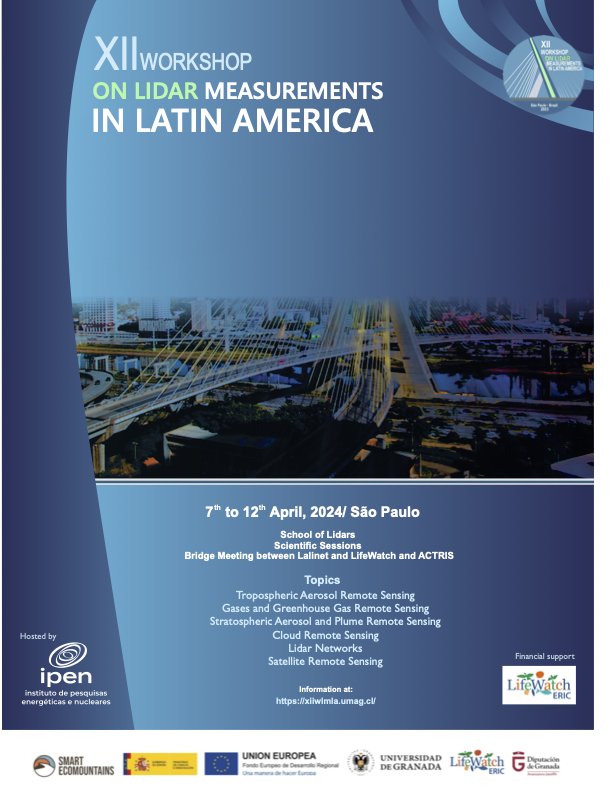
The XII WLMLA would be held in Sao Paulo, Brazil, from 7th to 12th of April 2024. This time we will have:
The XII WLMLA will be held in Sao Paulo, Brazil, from 7th to 12th of April 2024. This time we will have:
Due to unforeseen logistical drawbacks, the meeting had to be postponed. We apologize for any inconvenience caused and will provide further updates soon.
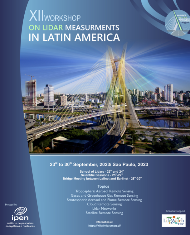
The XII WLMLA would be held in Sao Paulo, Brazil, from 23 to 30th of September 2023. This year we will have:
The XII WLMLA would be held in Sao Paulo, Brazil, from 7th to 12th of April 2024. This time we will have:
Due to unforeseen logistical complications, the meeting had to be postponed. We apologize for any inconvenience caused and will provide further updates soon.
Due to unforeseen logistical drawbacks, the meeting had to be postponed. We apologize for any inconvenience caused and will provide further updates soon.
The XII WLMLA would be held in Sao Paulo, Brazil, from 23 to 30th of September 2023. However, due to unforeseen logistical complications, the meeting had to be postponed. We apologize for any inconvenience caused and will provide further updates soon.
Due to unforeseen logistical complications, the meeting had to be postponed. We apologize for any inconvenience caused and will provide further updates soon.
This year we will have:
The XII WLMLA would be held in Sao Paulo, Brazil, from 23 to 30th of September 2023. This year we will have:
The XII WLMLA would be held in Sao Paulo, Brazil, from 23 to 30th of September 2023. However, due to unforeseen logistical complications, the meeting had to be postponed. We apologize for any inconvenience caused and will provide further updates soon.
The XII WLMLA would be held in Sao Paulo, Brazil, from 23 to 30th of September 2023. However, due to unforeseen logistical complications, the meeting had to be postponed. We apologize for any inconvenience caused and will provide further updates soon.
The XII WLMLA will be held in Sao Paulo, Brazil, from 23 to 30th of September 2023 . This year we will have:
The XII WLMLA would be held in Sao Paulo, Brazil, from 23 to 30th of September 2023. However, due to unforeseen logistical complications, the meeting had to be postponed. We apologize for any inconvenience caused and will provide further updates soon.
The XII WLMLA will be held in Sao Paulo, Brazil, from 23 to 30th of September 2023. This year we will have:
The XII WLMLA will be held in Sao Paulo, Brazil, from 23 to 30th of September 2023 . This year we will have:
https://xiwlmla.umag.cl/
https://xiiwlmla.umag.cl/
- Lidar School (23rd and 24th)
- Scientific Workshop (25th to 27th) and a
- Bridge Meeting with ACTRIS and LifeWatch (28th to 30th).
- Lidar School,
- Scientific Workshop, and
- Bridge Meeting with ACTRIS and LifeWatch.
The XII WLMLA will be held in Sao Paulo, Brazil, from 23 to 30th of September 2023. This year we will have the Lidar School (23rd and 24th), the Scientific Workshop (25th to 27th) and a Bridge Meeting with EARLINET (28th to 30th). More details on the event webpage:
The XII WLMLA will be held in Sao Paulo, Brazil, from 23 to 30th of September 2023. This year we will have:
- Lidar School (23rd and 24th)
- Scientific Workshop (25th to 27th) and a
- Bridge Meeting with ACTRIS and LifeWatch (28th to 30th).
More details on the event webpage:
Download Google Earth KML. Station map was last updated on 4/Apr/2019.
Download Google Earth KML. Station map updated on 4/Apr/2019.
Download Google Earth KML. Last updated on 4/Apr/2019.
Download Google Earth KML. Station map was last updated on 4/Apr/2019.
XI WLMLA
The XI WLMLA will be held in Sao Paulo, Brazil, from 23 to 30th of September 2023. This year we will have the Lidar School (23rd and 24th), the Scientific Workshop (25th to 27th) and a Bridge Meeting with EARLINET (28th to 30th). More details on the event webpage:
XII WLMLA
The XII WLMLA will be held in Sao Paulo, Brazil, from 23 to 30th of September 2023. This year we will have the Lidar School (23rd and 24th), the Scientific Workshop (25th to 27th) and a Bridge Meeting with EARLINET (28th to 30th). More details on the event webpage:
The XI WLMLA will be held in Sao Paulo, Brasil, from 23 to 30th of September 2023. More details on the event webpage:
The XI WLMLA will be held in Sao Paulo, Brazil, from 23 to 30th of September 2023. This year we will have the Lidar School (23rd and 24th), the Scientific Workshop (25th to 27th) and a Bridge Meeting with EARLINET (28th to 30th). More details on the event webpage:
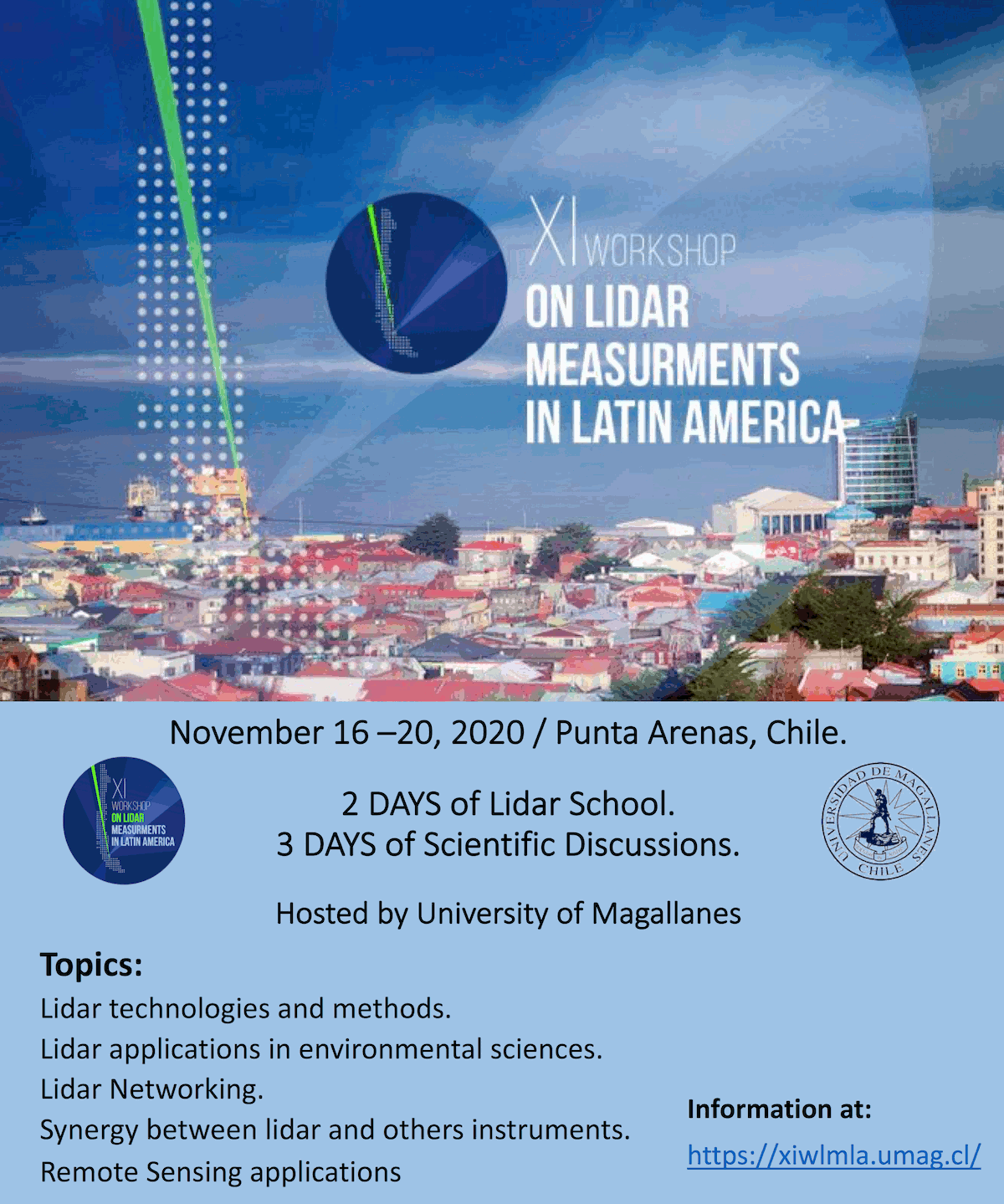
The XI WLMLA will be held in Punta Arenas, Chile, from 16th to 20th of November 2020. More details on the event webpage:
The XI WLMLA will be held in Sao Paulo, Brasil, from 23 to 30th of September 2023. More details on the event webpage:
X WLMLA
The X WLMLA will be held in Meddelin, Colombia, in the third week of November. More details on the event webpage:
http://ciencias.medellin.unal.edu.co/eventos/wlmla/index.php/2-institucional/6-home
Barclay Clemesha (22 October 2018)
Attach:CLEM.png Δ Δ After finishing his first degree at the University of London in 1957, Barclay Clemesha left his native England to work as an International Geophysical Year research assistant at University College Ibadan, Nigeria. Although he intended to return to work in the UK at the end of his eighteen-month contract, he has not done so.
After three years at Ibadan, working on the physics of the lower ionosphere, he moved to the University of Ghana, Accra, where he worked on F-region irregularities for 3 years. Working with a Radar he detected field aligned irregularities at equatorial region which only years after would be known as Equatorial Plasma Bubbles.
In 1963 he moved to the University of the West Indies, Kingston, Jamaica, where together with Geoffrey Kent and Ray Wright, he developed one of the first laser radars for atmospheric studies. He completed his Ph. D. at the University of the West Indies in 1968. While in Jamaica he participated of the First International Symposium of Equatorial Aeronomy in Peru and of the Second Symposium that took place at INPE, São José dos Campos, Brazil in 1966. There he knew Ida, at the time bilingual Secretary of the Symposium. They got married and after living in Jamaica to the end of 1968 they returned to Brazil and Dr. Clemesha started to work as Researcher at INPE and where he worked for the next 47 years.
His pioneering continued at INPE where he built the first Laser Radar (Lidar) of the Southern Hemisphere and measured Stratospheric Aerosols from 1969 to 1972. That time was also an era or great progress in Lasers Development and Dr. Clemesha built here at INPE an almost handmade Dye Laser used to measure Sodium, metal present in the upper atmosphere due to the incidence of meteors. His interests in Physics of The Upper Atmosphere did not limited to Lidars, but has extended also to experiments on board of sounding rockets, Airglow, and also to the measurements of wind and temperature in the upper atmosphere. Besides a productive scientist, professor and advisor we have lost also a great human being.
Dr. Paulo Prado Batista
Senior Researcher
Aeronomy Division INPE
Download Google Earth KML. Last updated on 28/Apr/2015.
Download Google Earth KML. Last updated on 4/Apr/2019.
Today we lost Barclay Clemesha (22 October 2018)
Barclay Clemesha (22 October 2018)
Dr. Paulo Prado Batista
Senior Researcher
Aeronomy Division INPE
Attach:CLEM.png Δ Δ After finishing his first degree at the University of London in 1957,
Attach:CLEM.png Δ Δ After finishing his first degree at the University of London in 1957,
Attach:CLEM.png Δ Δ After finishing his first degree at the University of London in 1957,
Attach:CLEM.png Δ Δ After finishing his first degree at the University of London in 1957,
Attach:clem.png Δ Δ After finishing his first degree at the University of London in 1957,
Attach:CLEM.png Δ Δ After finishing his first degree at the University of London in 1957,
Attach:CLEM.png Δ Δ After finishing his first degree at the University of London in 1957,
Attach:clem.png Δ Δ After finishing his first degree at the University of London in 1957,
After finishing his first degree at the University of London in 1957,
Attach:CLEM.png Δ Δ After finishing his first degree at the University of London in 1957,
Today we lost Barclay Clemesha (22 October 2018)
After finishing his first degree at the University of London in 1957, Barclay Clemesha left his native England to work as an International Geophysical Year research assistant at University College Ibadan, Nigeria. Although he intended to return to work in the UK at the end of his eighteen-month contract, he has not done so.
After three years at Ibadan, working on the physics of the lower ionosphere, he moved to the University of Ghana, Accra, where he worked on F-region irregularities for 3 years. Working with a Radar he detected field aligned irregularities at equatorial region which only years after would be known as Equatorial Plasma Bubbles.
In 1963 he moved to the University of the West Indies, Kingston, Jamaica, where together with Geoffrey Kent and Ray Wright, he developed one of the first laser radars for atmospheric studies. He completed his Ph. D. at the University of the West Indies in 1968. While in Jamaica he participated of the First International Symposium of Equatorial Aeronomy in Peru and of the Second Symposium that took place at INPE, São José dos Campos, Brazil in 1966. There he knew Ida, at the time bilingual Secretary of the Symposium. They got married and after living in Jamaica to the end of 1968 they returned to Brazil and Dr. Clemesha started to work as Researcher at INPE and where he worked for the next 47 years.
His pioneering continued at INPE where he built the first Laser Radar (Lidar) of the Southern Hemisphere and measured Stratospheric Aerosols from 1969 to 1972. That time was also an era or great progress in Lasers Development and Dr. Clemesha built here at INPE an almost handmade Dye Laser used to measure Sodium, metal present in the upper atmosphere due to the incidence of meteors. His interests in Physics of The Upper Atmosphere did not limited to Lidars, but has extended also to experiments on board of sounding rockets, Airglow, and also to the measurements of wind and temperature in the upper atmosphere. Besides a productive scientist, professor and advisor we have lost also a great human being.
VIII WLMLA
The local organising committee of the VIII WLMLA, held last April in Cayo Coco - Cuba, prepared a report Meeting Report. Please visit our Newsletter and Reports page for downloading the document.
For the Course Lectures, Science Presentations and Posters, please access them here: http://www.lalinet.org/viiiwlmla
Calbuco Volcano
http://media.npr.org/assets/img/2015/04/23/chile-calbuco_wide-ec9dce33f74a4c1970f589af2e55b56d580a68f9-s800-c85.jpg | Chile's Calbuco volcano is seen from the town of Puerto
Montt on Wednesday, April 22, 2015, as it spews a high
column of ash and lava.
Photo: Diego Main/AFP/Getty Images LINK
Many of our Lidar stations are in the region affected by the Calbuco Volcano. For more information on our measurements, please see our special page on the Calbuco volcano eruption.
X WLMLA
The X WLMLA will be held in Meddelin, Colombia, in the third week of November. More details on the event webpage:
http://ciencias.medellin.unal.edu.co/eventos/wlmla/index.php/2-institucional/6-home
The Latin America Lidar Network (LALINET a.k.a ALINE) is a Latin American coordinated lidar network, established in 2001, measuring aerosol backscatter coefficient and aerosol extinction profiles for climatological studies of the aerosol distribution over Latin America, as well as other atmospheric species such as ozone and water vapor. This federative lidar network aims to establish a consistent and statistically sound database for enhancement of the understanding of the aerosol distribution over the continent and its direct and indirect influence on climate.
The Latin America Lidar Network (LALINET a.k.a ALINE) is a Latin American coordinated lidar network measuring aerosol backscatter coefficient and aerosol extinction profiles for climatological studies of the aerosol distribution over Latin America, as well as other atmospheric species such as ozone and water vapor. This federative lidar network aims to establish a consistent and statistically sound database for enhancement of the understanding of the aerosol distribution over the continent and its direct and indirect influence on climate.
(:Title LALINET or ALINE:)
(:Title LALINET:)
For the Course Lectures, Science Presentations and Posters, please access them here:http://www.lalinet.org/viiiwlmla
For the Course Lectures, Science Presentations and Posters, please access them here: http://www.lalinet.org/viiiwlmla
For the Course Lectures, Science Presentations and Posters, please access them here.http://www.lalinet.org/viiiwlmla
For the Course Lectures, Science Presentations and Posters, please access them here:http://www.lalinet.org/viiiwlmla
For the Course Lectures, Science Presentations and Posters, please access them here.http://www.lalinet.org/viiiwlmla
The local organising committee of the VII WLMLA, held last April in Cayo Coco - Cuba, prepared a report Meeting Report. Please visit our Newsletter page for downloading the document.
http://lalinet.org/uploads/Aline/Newsletter/VIII_Cuba_WLMLA_Meeting_Report_2015.pdf
VIII WLMLA
The local organising committee of the VIII WLMLA, held last April in Cayo Coco - Cuba, prepared a report Meeting Report. Please visit our Newsletter and Reports page for downloading the document.
The local organising committee of the VII WLMLA, held last April in Cayo Coco - Cuba, prepared a report Meeting Report. Please visit our Newsletter page for downloading the document.
http://lalinet.org/uploads/Aline/Newsletter/VIII_Cuba_WLMLA_Meeting_Report_2015.pdf
http://media.npr.org/assets/img/2015/04/23/chile-calbuco_wide-ec9dce33f74a4c1970f589af2e55b56d580a68f9-s800-c85.jpg | Chile's Calbuco volcano is seen from the town of Puerto \\
http://media.npr.org/assets/img/2015/04/23/chile-calbuco_wide-ec9dce33f74a4c1970f589af2e55b56d580a68f9-s800-c85.jpg | Chile's Calbuco volcano is seen from the town of Puerto \\
http://media.npr.org/assets/img/2015/04/23/chile-calbuco_wide-ec9dce33f74a4c1970f589af2e55b56d580a68f9-s800-c85.jpg | Chile's Calbuco volcano is seen from the town of Puerto \\
http://media.npr.org/assets/img/2015/04/23/chile-calbuco_wide-ec9dce33f74a4c1970f589af2e55b56d580a68f9-s800-c85.jpg | Chile's Calbuco volcano is seen from the town of Puerto \\
Many of our Lidar stations are in the region affected by the Calbuco Volcano. For more information on our measurements, please see our special page on the Calbuco volcano eruption.
column of ash and lava. Photo: Diego Main/AFP/Getty Images
column of ash and lava.
Photo: Diego Main/AFP/Getty Images LINK
http://media.npr.org/assets/img/2015/04/23/chile-calbuco_wide-ec9dce33f74a4c1970f589af2e55b56d580a68f9-s800-c85.jpg | Chile's Calbuco volcano is seen from the town of
Puerto Montt on Wednesday, as it spews a high \\
http://media.npr.org/assets/img/2015/04/23/chile-calbuco_wide-ec9dce33f74a4c1970f589af2e55b56d580a68f9-s800-c85.jpg | Chile's Calbuco volcano is seen from the town of Puerto
Montt on Wednesday, April 22, 2015, as it spews a high \\
http://media.npr.org/assets/img/2015/04/23/chile-calbuco_wide-ec9dce33f74a4c1970f589af2e55b56d580a68f9-s800-c85.jpg | Chile's Calbuco volcano is seen from the town of Puerto Montt on Wednesday, as it spews a high column of ash and lava. Diego Main/AFP/Getty Images
http://media.npr.org/assets/img/2015/04/23/chile-calbuco_wide-ec9dce33f74a4c1970f589af2e55b56d580a68f9-s800-c85.jpg | Chile's Calbuco volcano is seen from the town of
Puerto Montt on Wednesday, as it spews a high
column of ash and lava. Photo: Diego Main/AFP/Getty Images
http://media.npr.org/assets/img/2015/04/23/chile-calbuco_wide-ec9dce33f74a4c1970f589af2e55b56d580a68f9-s800-c85.jpg | teste
http://media.npr.org/assets/img/2015/04/23/chile-calbuco_wide-ec9dce33f74a4c1970f589af2e55b56d580a68f9-s800-c85.jpg | Chile's Calbuco volcano is seen from the town of Puerto Montt on Wednesday, as it spews a high column of ash and lava. Diego Main/AFP/Getty Images
http://media.npr.org/assets/img/2015/04/23/chile-calbuco_wide-ec9dce33f74a4c1970f589af2e55b56d580a68f9-s800-c85.jpg | teste
http://media.npr.org/assets/img/2015/04/23/chile-calbuco_wide-ec9dce33f74a4c1970f589af2e55b56d580a68f9-s800-c85.jpg | teste
http://media.npr.org/assets/img/2015/04/23/chile-calbuco_wide-ec9dce33f74a4c1970f589af2e55b56d580a68f9-s800-c85.jpg | teste
http://media.npr.org/assets/img/2015/04/23/chile-calbuco_wide-ec9dce33f74a4c1970f589af2e55b56d580a68f9-s800-c85.jpg | teste
http://media.npr.org/assets/img/2015/04/23/chile-calbuco_wide-ec9dce33f74a4c1970f589af2e55b56d580a68f9-s800-c85.jpg | teste
http://media.npr.org/assets/img/2015/04/23/chile-calbuco_wide-ec9dce33f74a4c1970f589af2e55b56d580a68f9-s800-c85.jpg | teste
http://media.npr.org/assets/img/2015/04/23/chile-calbuco_wide-ec9dce33f74a4c1970f589af2e55b56d580a68f9-s800-c85.jpg | teste
http://media.npr.org/assets/img/2015/04/23/chile-calbuco_wide-ec9dce33f74a4c1970f589af2e55b56d580a68f9-s800-c85.jpg | teste
http://media.npr.org/assets/img/2015/04/23/chile-calbuco_wide-ec9dce33f74a4c1970f589af2e55b56d580a68f9-s800-c85.jpg | teste